| The Geography of Oceana | |
|---|---|
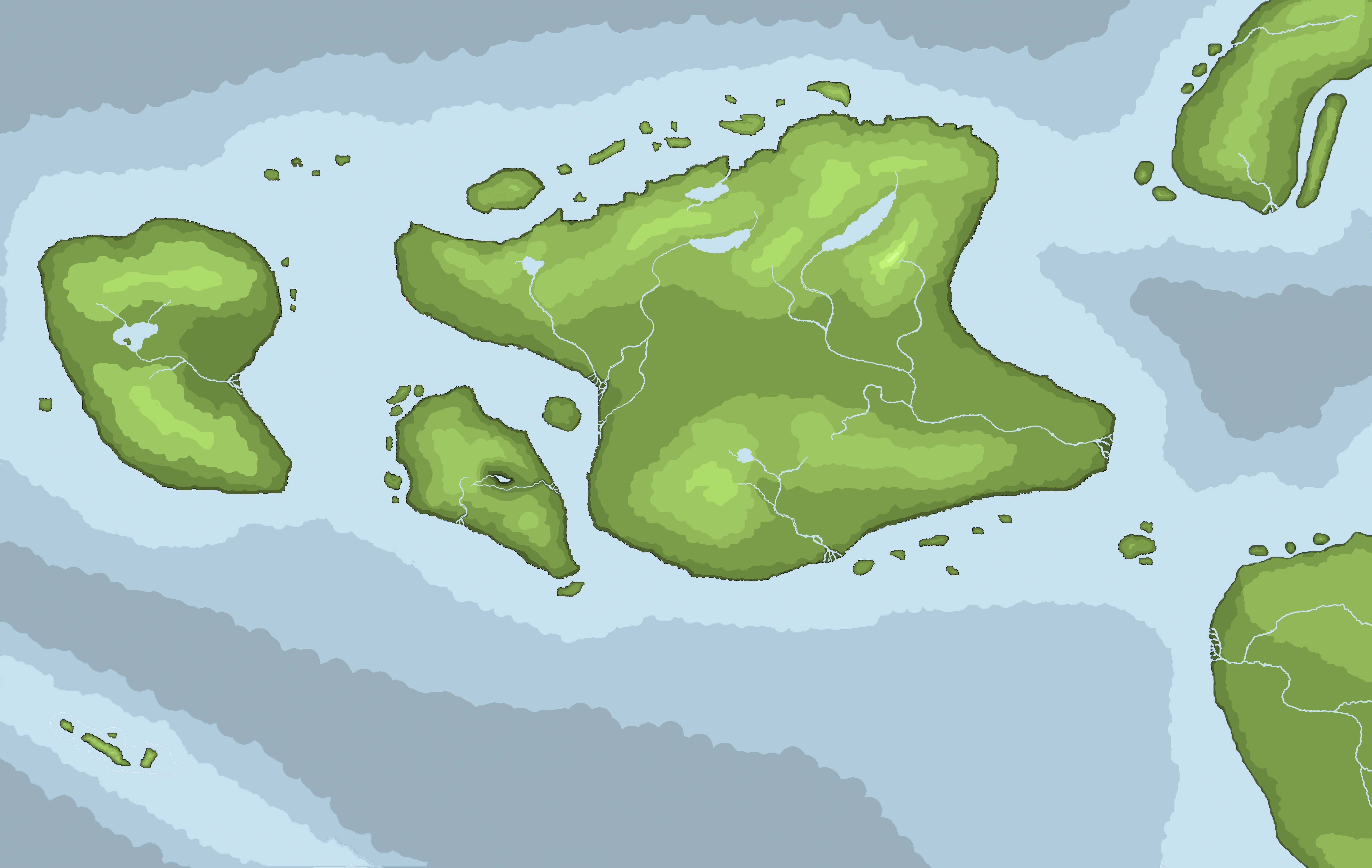 Islands of Oceanid Archipelago and neighboring landmasses | |
|
Continent |
Erebeia |
|
Region |
Western Erebeia |
|
Area |
113,102 sq km 43,339 sq mi % land % water |
|
Coastline |
|
|
Borders |
0 km |
|
Highest Point |
Mount Celia 1,412 m (4,632 ft) |
|
Lowest Point |
Paircythraul (The Cynopean Bowl) -2m |
|
Longest River |
The Halcyona 311 km (193 mi) |
|
Largest Lake |
Lake Alma 56.7 sq km (21.9 sq mi) |
With an area of roughly 43,669 square miles (113,102 square kilometers), the Republic of Oceana is centered around the Oceanid Archipelago including the major Islands of Panopea, Cynopea, the Oceana-Marpesium and a number of smaller Islands.
The Republic lies between the Northern Ocean, the Southern Sea and the Gulf of Veneta. It comes within 66 miles (106 kilometers) of the northwest coast of Neustria, from which it is seperated by the Oceanic Channel. To the Northeast of the Oceana-Marpesium, the republic comes within 70 miles (112 kilometers) of the tip of the Venetan Peninsula. Oceana (Harug) - Neustria 31mi
Oceana (Thessi) - Neustria 32mi
Oceana - Neustria 66mi
Oceana - Veneta 70mi
Oceana - Veneta islands 55mi
Area
The total area of the Republic of Oceana is approximately 43,669 square miles (113,102 square km) comprising the islands of Oceana Marpesium, Panopea, Cynopea and smaller Islands. The Oceana-Marpesium is the largest Island, at 30,675 square miles (79,447 sq km) accounting for just under three quarters of the total landmass of the country. Panopea at 8,122 square miles (21,035 sq km), is the second largest, accounting for about a fifth of the total landmass. Cynopea is much smaller covering only 3,171 square miles (8,212 sq km).
| Rank | Name | Area | |
|---|---|---|---|
| 1 | Oceana-Marpesium | 30,675 sq mi | 79,447 sq km |
| 2 | Panopea | 8,122 sq mi | 21,035 sq km |
| 3 | Cynopea | 3,171 sq mi | 8,212 sq km |
| 4 | Raasa | 392 sq mi | 1,015 sq km |
| 5 | Isle of Maud | 157 sq mi | 406 sq km |
| 6 | Thessi | 105 sq mi | 272 sq km |
| 7 | Durey | 101 sq mi | 262 sq km |
| 8 | Harey | 98 sq mi | 254 sq km |
| 9 | Skari | 59 sq mi | 153 sq km |
| 10 | The Childe | 40 sq mi | 104 sq km |
| Republic of Oceana | 45,553 sq mi | 117,981 sq km | |
Physical Geography
The Physical geography of Oceana is varied but is largely mountainous. Oceana itself is mostly lowland terrain centred around the Clutha and Halciona river valleys in the west and east respectively, with the Oceana highlands to the south. The Geography of Marpesia is dominated by the Marpesian Highlands, which contain the tallest mountains and largest lakes in the republic. The Geography of Cynopea is almost entirely mountainous bar a the Cynopean Bowl, a large circular river valley. The Geography of Panopea includes several mountain ranges and numerous small lakes.
The overall geomorphology of the Republic was shaped by the combined forces of tectonics and climate change, in particular glaciation.
Mountains & Hills
Rivers and Lakes
Coastline & Islands
Coastline
Islands
In total, it is estimated that the Oceananid Archipelago is made up of over one hundred small islands, some being natural and some being man-made.
Islands of Oceana
The Islands of Oceana can be divided into three groupings. There are the 'Channel Islands', which sit in the Oceanid Channel between Oceana and Neustra. The second group are the 'Southern Isles' which are an Island chain along the southern coast of the Oceana-Marpesium. The third group is the Isle of Maud, which sits in the Cynopean Channel between the Oceana-Marpesium and Cynopea.
Islands of Marpesia
Marpesia is home to the largest island chain in the republic. Comparising nearly half the islands in the Archaepelago the 'Marpsesian Hebrides' are strung out along the Northern coast of the Oceana Marpesium and contain some of the largest independant Islands in the republic.
Islands of Cynopea
Cynopea has multiple islands along its northwest coast known as the 'Carregs' which are incredibly rocky. Off the south-eastern tip of Cynopea lies 'The Childe', a small but fertile Island which broke off relatively recently (within the past two millenia) from Cynopea in what is known by the natives as 'The Birth'.
Climate
Human Geography
Demographics
Political Geography
Economic Geography
Natural Resources
70.1 per sq km
181.8 per sq mi
population = 8,279,325
Oceana Glaschu = 3,063,350 (37%) 5.9 - 6
Oceana Emporium = 2,483,797 (30%) 4.8 - 5
Panopea = 1,490,278 (18%) 2.88 - 2
Marpesia = 993,519 (12%) 1.92 - 2
Cynopea = 248,380 (3%) 0.48 - 1
Statistics
Location
don't need?
Geographic coordinates
don't need?
Map references
don't need?
Area
total: 113,102 sq km (43,669 sq mi)
land: 110,040 sq km (42,487 sq mi)
water: 3,061 sq km (1,182 sq mi)
Area - comparative
don't need?
Land boundaries
total: ## km / ## mi
border countries
don't need?
Coastline
km / ## mi
Maritime claims
territorial sea: 12 nm (in the Gulf of Veneta # nm)
contiguous zone: 24 nm
exclusive fishing zone: 200 nm; extends to continental shelf boundary with Veneta and Neustria.
continental shelf: 200 m depth or to the depth of exploitation
Climate
???????????
Terrain
Elevation extremes
lowest point: Cynopean Bowl -2 m
highest point: Mount Celia 1,412 m / 4,632 ft
Natural resources
timber, iron ore, copper, lead, zinc, chromite, nickel, gold, silver, limestone, peet
Land use
arable land: #%
permanent crops: #%
other: #% (year)
Irrigated land
sq km (year)
Total renewable water resources
cu km (year)
Freshwater withdrawal (domestic/industrial/agricultural)
total: # cu km/yr (#%/#%/#3%)
per capita: # cu m/yr (year)
Natural hazards
NA (dormant volcanoes on Islas de Fuego)
Environment - current issues
air pollution from manufacturing and power plants contributing to acid rain; water pollution from industrial wastes, agricultural chemicals; habitat loss threatens wildlife populations
Environment - international agreements
don't need?
Geography - note
(trivia)